This page was generated from 3dhp.ipynb.
Interactive online version:
USGS 3DHP#
[1]:
from __future__ import annotations
import shapely
from pynhd import HP3D, NLDI
USGS 3DHP web service has five layers: hydrolocation, flowline, waterbody, drainage_area, and catchment. Let’s start by getting the closest flowline within a 10 m radius of a point.
[2]:
nhd3d = HP3D("flowline")
point = shapely.Point(-89.441, 43.487)
flw = nhd3d.bygeom(point, distance=10)
flw.explore()
[2]:
Make this Notebook Trusted to load map: File -> Trust Notebook
Next, we use NLDI to get the basin boundary of a NHD flowline and use it to query different layers of the 3DHP web service.
[3]:
comid = "937070225"
basin = NLDI().get_basins(comid, "comid")
basin.explore()
[3]:
Make this Notebook Trusted to load map: File -> Trust Notebook
[4]:
nhd3d = HP3D("flowline")
network = nhd3d.bygeom(basin.geometry.iloc[0])
network.explore()
[4]:
Make this Notebook Trusted to load map: File -> Trust Notebook
[5]:
nhd3d = HP3D("waterbody")
water = nhd3d.bygeom(basin.geometry.iloc[0])
water.explore()
[5]:
Make this Notebook Trusted to load map: File -> Trust Notebook
We can also query the service using mainstems.
[6]:
dm = ("https://geoconnex.us/ref/mainstems/323742", "https://geoconnex.us/ref/mainstems/312091")
nhd3d = HP3D("flowline")
down_mains = nhd3d.byids("mainstemid", dm)
down_mains.explore()
[6]:
Make this Notebook Trusted to load map: File -> Trust Notebook
Or using NHD ReachCode.
[7]:
reachcode = "07070004002889"
nhd3d = HP3D("hydrolocation_reach")
hydrolocation = nhd3d.byids("universalreferenceid", reachcode)
hydrolocation
[7]:
| geometry | OBJECTID | id3dhp | featuredate | mainstemid | universalreferenceid | gnisid | gnisidlabel | featuretype | featuretypelabel | edhuniqueid | workunitid | |
|---|---|---|---|---|---|---|---|---|---|---|---|---|
| 0 | POINT (-89.44179 43.48829) | 5800707 | 01HAJW7 | 1694649600000 | https://geoconnex.us/ref/mainstems/359842 | 07070004002889 | None | None | 10 | Reachcode Start | None | None |
| 1 | POINT (-89.43904 43.48568) | 25271902 | 01SVVYQ | 1694649600000 | https://geoconnex.us/ref/mainstems/359842 | 07070004002889 | None | None | 11 | Reachcode End | None | None |
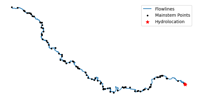
Let’s query flowlines and hydrolocations for a list of mainstems.
[8]:
nhd3d = HP3D("hydrolocation_reach")
mainstem_points = nhd3d.byids("mainstemid", hydrolocation["mainstemid"].to_list())
nhd3d = HP3D("flowline")
mainstem_lines = nhd3d.byids("mainstemid", hydrolocation["mainstemid"].to_list())
ax = mainstem_lines.plot(zorder=0, figsize=(8, 8))
mainstem_points.plot(ax=ax, color="k", markersize=8)
hydrolocation.plot(ax=ax, color="r", markersize=60, marker="*")
ax.legend(["Flowlines", "Mainstem Points", "Hydrolocation"])
ax.set_axis_off()
ax.figure.savefig("_static/hydrolocation.png", bbox_inches="tight", dpi=300)
